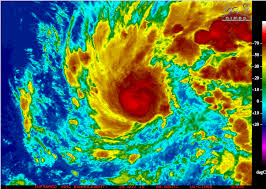
Sandra has intensified to major hurricane strength over the Pacific Ocean with maximum winds near 115 mph.
She is spinning about 560 miles off the west coast of Mexico.
There are currently no coastal watches or warnings in effect.
Interests in southern portions of the Baja California peninsula should monitor the progress of Sandra. Tropical storm or hurricane watches may be required for portions of this area tonight or on Thursday.
At 200 PM MST (2100 UTC), the eye of Hurricane Sandra was located near latitude 13.0 North, longitude 109.9 West. Sandra is moving toward the northwest near 8 mph (13 km/h) and this motion is expected to continue through tonight.
A turn toward the north- northwest is forecast on Thursday, followed by a northward turn Thursday night.
Maximum sustained winds have increased to near 115 mph (185 km/h) with higher gusts. Sandra is a category 3 hurricane on the Saffir-Simpson Hurricane Wind Scale. Additional strengthening is anticipated during the next 12 to 24 hours, but weakening should commence sometime on Thursday or Thursday night.
Hurricane force winds extend outward up to 25 miles (35 km) from the center, and tropical storm force winds extend outward up to 90 miles (150 km).

