
Dangerous Category 4 Hurricane Florence likely to stall and pound Carolinas, Virginia for days
More than 5.4 million people on East Coast under hurricane warnings or watches
Virginia, Maryland, North Carolina and South Carolina are all under a state of emergency as Hurricane Florence churns toward the east coast.
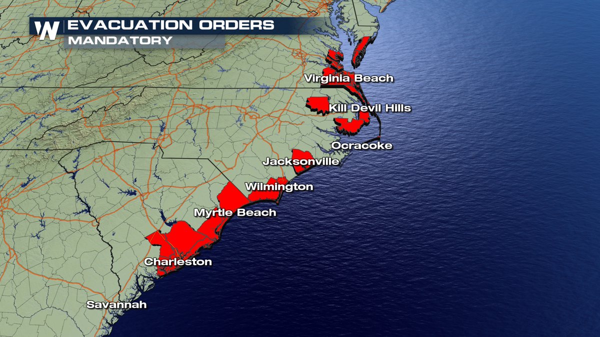
More than one million residents are currently under mandatory evacuation. Notably, S.C. Governor Henry McMaster ordered the evacuation of all coastal South Carolina residents as the storm approaches.
North Carolina Gov. Cooper said in a press conference, “The state to our knowledge has never issued an evacuation order. This is the first one of its kind and I have –– am issuing it for the Barrier Islands.”
SCHP flush cars leading traffic from Charleston to Columbia in the reversed lane. #Florence
???????????????????????????? pic.twitter.com/xML8vpBP3A— Trooper Bob (@TrooperBob_SCHP) September 11, 2018
The storm quickly escalated from a Category 1 to a Category 4 hurricane on Monday. Data from a NOAA Hurricane Hunter aircraft indicate that Florence has continued to rapidly strengthen and has maximum sustained winds near 130 mph.
The storm will likely make landfall Thursday—affecting more than one million people. Rainfall could reach 2 feet in some locations, officials predict.
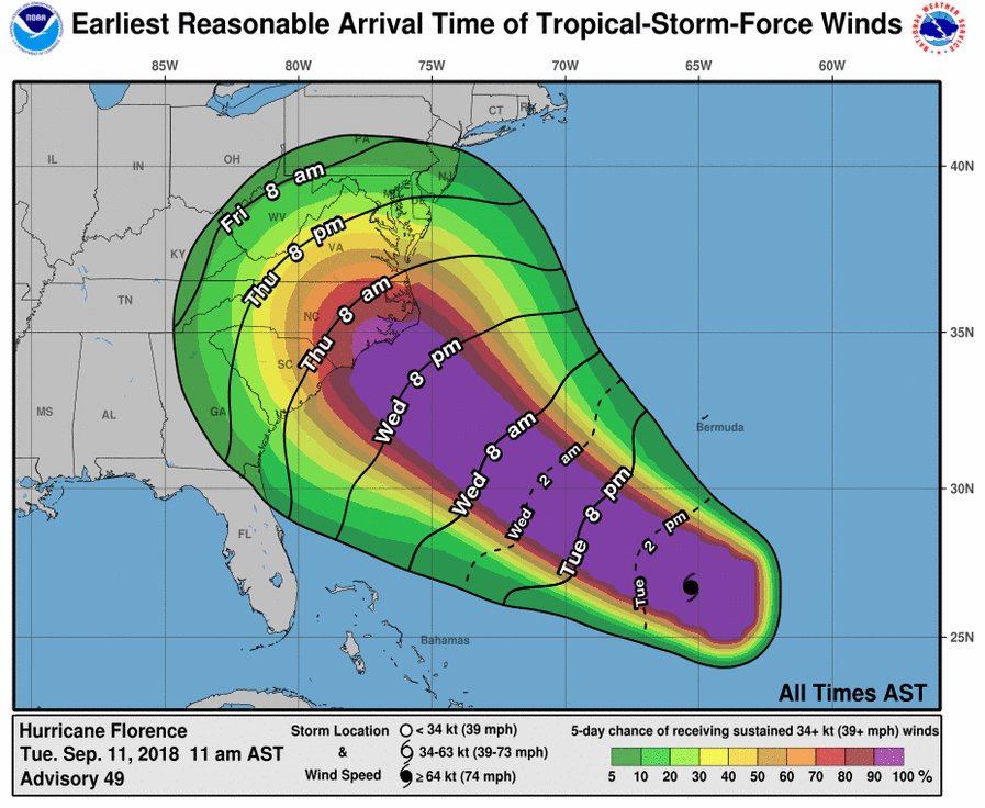
The earliest reasonable time that tropical-storm-force winds could arrive in the United States from Florence is late Wednesday, and the most likely time is Thursday morning.
“On the forecast track, the center of Florence will move over the southwestern Atlantic Ocean between Bermuda and the Bahamas through Wednesday, and approach the coast of North Carolina or South Carolina in the hurricane watch area Thursday and Friday,” the National Hurricane Center said.
“Florence is a category 4 hurricane on the Saffir-Simpson Hurricane Wind Scale and is expected to begin re-strengthening later today and continue a slow strengthening trend for the next day or so. While some weakening is expected on Thursday, Florence is expected to be an extremely dangerous major hurricane through landfall.”
“It appears a major flood event is on the way in the Middle Atlantic region,” meteorologist Mike Smith said. “It is likely some areas will flood that have never flooded before.”
For more information on the local hazards from #Florence, follow the @NWS offices on Twitter: @NWSCharlestonSC @NWSMoreheadCity @NWSRaleigh @NWSWilmingtonNC @NWSColumbia @NWSGSP @NWSWakefieldVA @NWSBlacksburg @NWS_BaltWash @NWS @NWSCharlestonWV pic.twitter.com/LNh3TGvCcd
— National Hurricane Center (@NHC_Atlantic) September 11, 2018

The National Hurricane Center warns category 4 storms are ‘catastrophic’: “Well-built framed homes can sustain severe damage with loss of most of the roof structure and/or some exterior walls,” the hurricane center said. “Most trees will be snapped or uprooted and power poles downed. Fallen trees and power poles will isolate residential areas. Power outages will last weeks to possibly months. Most of the area will be uninhabitable for weeks or months.”
WATCH LIVE:
RESIDENTS IN ALL COASTAL EVACUATION ZONES IN ALL COUNTIES MUST EVACUATE BEGINNING NOON TOMORROW, TUESDAY, SEPTEMBER 11, 2018 DUE TO HURRICANE #FLORENCE #SCTWEETS #SCWX https://t.co/YEtFfgLQXe #alert
— SCEMD (@SCEMD) September 10, 2018
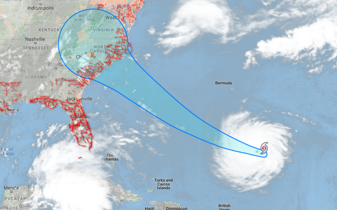
If Florence makes landfall as a Category 4 in North Carolina, it will be the largest storm to strike that far north ever on record.
If the latest NHC forecast comes to pass, #Florence will be the only hurricane on record to make a Cat 4 U.S. landfall so far north. The dramatic slowing on Friday, and the implied risk of extreme rainfall, is the other very concerning detail on this map. https://t.co/tfePz2Glur pic.twitter.com/NPrkaWL6Ha
— Bob Henson (@bhensonweather) September 10, 2018
NOAA’s WP-3D Orion (#NOAA42) and Gulfstream-IV (#NOAA49) are flying missions today to survey Hurricane #Florence. Check out this video from yesterday’s P-3 flight into #Florence. Stay up to date on all hurricane activity at https://t.co/MlZk25kG0d. Video: Nick Underwood/NOAA pic.twitter.com/MZXhiJWvVh
— NOAA Aircraft Operations Center (@NOAA_HurrHunter) September 10, 2018
Earlier this morning, @Astro_Ricky Arnold shared this view, saying “Hurricane #Florence this morning as seen from @Space_Station.” Our @NASAEarth-observing satellites also continue to monitor this storm as it has developed an eye + strengthened: https://t.co/OQmhIyvaYQ pic.twitter.com/Npp0Zwb0cf
— NASA (@NASA) September 10, 2018
WATCH: FEMA associate administrator for response and recovery Jeffrey Byard warned residents of the Carolinas and Virginia region to prepare for the strongest storm “in decades” when Hurricane Florence makes landfall on Thursday.
You can find more information from the National Hurricane Center by clicking here.
Follow @Breaking911 for the latest developments.