
Satellite images show some increase in organization of the cloud pattern with very deep convection near the center and outflow in all quadrants, suggesting that the cyclone is strengthening. An eye has not been depicted in conventional imagery, but it was noted in earlier microwave data. Intensification was confirmed by an Air Force plane which reported an earlier peak of 89 kt at flight level and a recent peak of 80 kt measured by the SFMR.
The flight level winds were lower in the most recent leg. The minimum pressure was near 981 mb near 0000 UTC, but then rose to 985 mb by 0200 UTC. Based on reports from the plane, the initial intensity has been set at 75 kt. There is an opportunity for Franklin to pick up a little more strength or fluctuate in intensity before landfall tonight or early Thursday. Once the hurricane moves inland over the high terrain, rapid weakening should begin. Regardless of weakening, the cyclone will likely bring torrential rains with flash flooding and mud slides along its path.
Franklin is moving toward the west or 270 degrees at 11 kt. The hurricane is trapped within the easterly flow around a strong high pressure system over Mexico and the southwestern United States. This pattern will force Franklin to move on the same general westward track toward the coast of Mexico and then inland until dissipation.
Latest advisory from the National Hurricane Center:
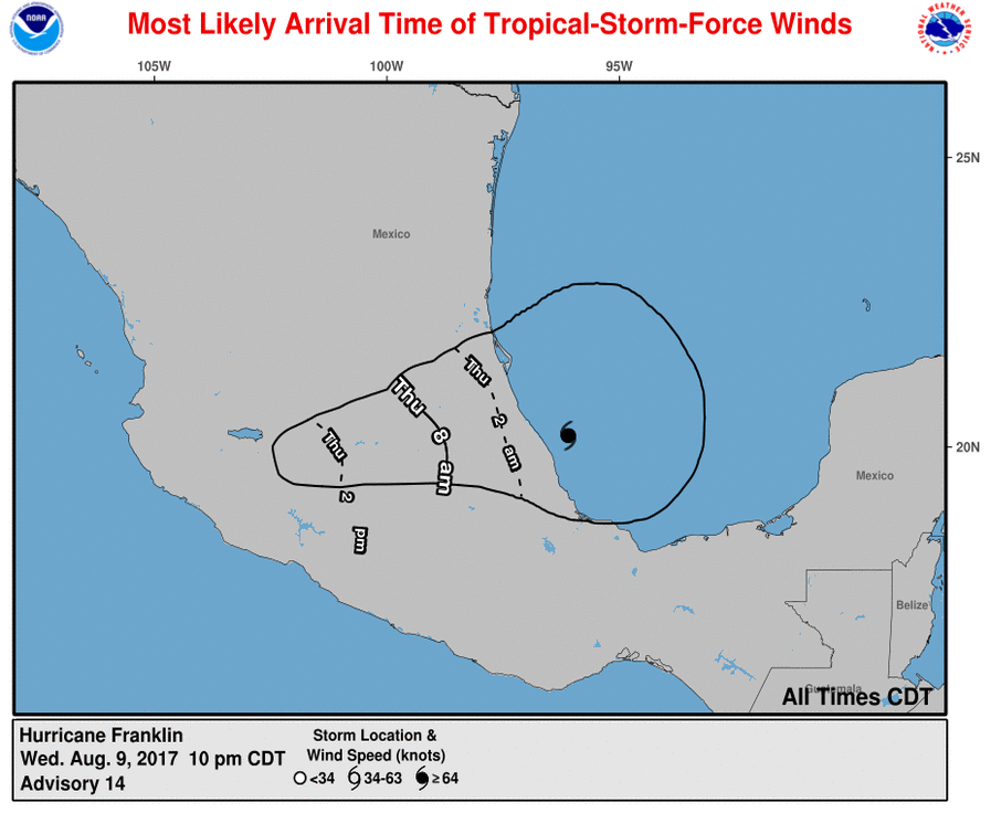
...HURRICANE FRANKLIN EXPECTED TO MAKE LANDFALL IN THE NEXT
SEVERAL HOURS ACCOMPANIED BY TORRENTIAL RAINS...


SUMMARY OF 1000 PM CDT...0300 UTC...INFORMATION
-----------------------------------------------
LOCATION...20.2N 96.1W
ABOUT 100 MI...160 KM ESE OF TUXPAN MEXICO
ABOUT 70 MI...110 KM N OF VERACRUZ MEXICO
MAXIMUM SUSTAINED WINDS...85 MPH...140 KM/H
PRESENT MOVEMENT...W OR 270 DEGREES AT 13 MPH...20 KM/H
MINIMUM CENTRAL PRESSURE...985 MB...29.09 INCHES


WATCHES AND WARNINGS
--------------------
CHANGES WITH THIS ADVISORY:

None.

SUMMARY OF WATCHES AND WARNINGS IN EFFECT:

A Hurricane Warning is in effect for...
* The coast of Mexico from Puerto de Veracruz to Cabo Rojo

A Hurricane Watch is in effect for...
* The coast of Mexico north of Cabo Rojo to Rio Panuco

A Tropical Storm Warning is in effect for...
* The coast of Mexico south of Puerto de Veracruz to Puerto Dos
Bocas
* The coast of Mexico north of Cabo Rojo to Barra del Tordo

A Hurricane Warning means that hurricane conditions are expected
somewhere within the warning area.  Preparations to protect life and
property should be rushed to completion.

A Hurricane Watch means that hurricane conditions are possible
within the watch area.

A Tropical Storm Warning means that tropical storm conditions are
expected somewhere within the warning area.

For storm information specific to your area, please monitor
products issued by your national meteorological service.


DISCUSSION AND 48-HOUR OUTLOOK
------------------------------
At 1000 PM CDT (0300 UTC), the center of Hurricane Franklin was
located near latitude 20.2 North, longitude 96.1 West. Franklin is
moving toward the west near 13 mph (20 km/h), and this general
motion is expected to continue during the next day or so. On the
forecast track, the center of Franklin is anticipated to cross the
coast of the Mexican state of Veracruz in the next several hours.

Data from an Air Force reconnaissance plane indicate that the
maximum sustained winds are near 85 mph (140 km/h) with higher
gusts. Some fluctuations in intensity are likely before landfall,
but the hurricane should weaken rapidly as it moves farther inland.

Hurricane-force winds extend outward up to 35 miles (55 km) from the
center and tropical-storm-force winds extend outward up to 150 miles
(240 km). La Vigueta, Veracruz recently reported a wind gust of 45
mph (72 km/h).

The minimum central pressure recently estimated by an Air Force
plane was 985 mb (29.09 inches).


HAZARDS AFFECTING LAND
----------------------
RAINFALL:  Rainfall totals of 4 to 8 inches with isolated maximum
amounts of 15 inches are possible across the Mexican states of
Tabasco, northern Veracruz, northern Puebla, Tlaxacala, Hidalgo,
Queretar and eastern San Luis Potosi in eastern Mexico.  These rains
will be capable of producing life-threatening flash floods and
mudslides.

WIND:  Hurricane conditions are expected to reach the coast within
the Hurricane Warning area in the next few hours. Preparations to
protect life and property should be rushed to completion.

Tropical storm conditions are expected across portions of the
Tropical Storm Warning area along the southern shore of the Bay of
Campeche through tonight and early Thursday.  Hurricane conditions
are possible within the Hurricane Watch area in the next several
hours. Tropical storm conditions are expected within the Tropical
Storm Warning area in eastern Mexico in the next several hours.

STORM SURGE:  A dangerous storm surge will raise water levels by
as much as 4 to 6 feet above normal tide levels along the
immediate coast near and to the north of where the center makes
landfall in the Hurricane Warning area.  Near the coast, the
surge will be accompanied by large and destructive waves.
Most Likely Wind Arrival Time:
Warning Cone:
