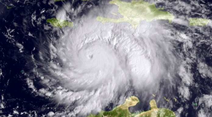
Hurricane Matthew is on course to batter the Florida, Georgia and South Carolina coasts while the chances of it reaching the Mid-Atlantic and Northeast fell overnight.
Matthew, a Category 3 storm on the Saffir-Simpson scale with top winds of 115 miles (185 kilometers) per hour, has forced the closure of the Buckeye oil terminal in Freeport, Bahamas, and could also disrupt oil shipments throughout the East Coast as other ports close. The National Weather Service warned its high winds, heavy rain and storm surge could kill people who haven’t sought shelter, wash out roads, cut communications links and touch off widespread power outages that could last weeks.
“The big thing is that Northeast gets spared, which is good and bad because they actually needed the rain, and the Outer Banks too.” said Evan Duffey, a meteorologist at AccuWeather in State College, Pennsylvania. “Regardless, the Bahamas and Florida are going to see a deteriorating situation throughout the day. Landfall is still possible in Florida.”
Florida, Georgia and South Carolina have urged residents to prepare for the storm and leave homes that could take a direct strike. Utilities across the region have repair crews standing by to respond to power outages.
Juno Beach, Florida-based NextEra Energy Inc. said Tuesday it was mobilizing a 6,300-member repair force and pre-positioning equipment ahead of the storm. Customers were urged to prepare for repeated blackouts from trees falling on power lines.
In Florida, a hurricane warning covers Lake Okeechobee and the coast from Golden Beach to Sebastian Inlet. Warnings have also been issued throughout the Caribbean and the Bahamas as well where the storm is still battering Haiti and eastern Cuba and is nearing Long Island, Bahamas.
About 55,000 people who lost their homes in a 2010 earthquake are still living in shelters across Haiti, the United Nations said in a statement. Haiti will be vulnerable to landslides for days to come, Duffey said.
Matthew was 45 miles east-northeast of Cabo Lucrecia, Cuba, according to an 8 a.m. U.S. National Hurricane Center advisory. It is forecast to strengthen back to a Category 4 system as it nears Florida Friday.
On its current forecast track, Matthew should move up Florida’s east coast just off shore. Any deviation could mean the difference between massive devastation and essentially missing the state.
“It will likely take another day or so for the potential impacts of Matthew in the United States to fully clarify,” Daniel Brown, the Miami center’s warning-coordination meteorologist, wrote in an analysis Wednesday.
Residents across southern Florida should “aggressively prepare” for the storm, which has a high chance of killing people caught in the open, tearing the roofs off homes and buildings, washing out roads and bridges and causing wide-spread power outages that could last weeks, according to the National Weather Service.
As much as 10 inches (25 centimeters) of rain could fall in parts of Florida, the hurricane center said.
Earlier forecasts called for an upper-level weather pattern to grab Matthew and drag it north up the East Coast, Duffey said. It looks now that the storm will drift away from the U.S. and back out to sea through the weekend, though some models have it looping back around to take another pass through the Bahamas.
Featured Image: Twitter
(c) 2016, Bloomberg · Brian K. Sulliva

